
Land Development
Land development issues are largely the domain of civil engineers and surveyors but anyone will benefit from the help of our knowledgeable geologists. There are several regulatory requirements that may be imposed on your land subdivision or development for which geologists are uniquely qualified.
Land Development Services
Should you require any of the following services, GeoServices, Ltd. can help.
Slope Stability Studies
Rock Slope Stability
 Rock Slope stability studies assess potential rock slope failures as a result of planar geologic conditions, such as strike and dip, joints, and faults. These studies require measurements of geologic features at nearby bedrock exposures to assess the potential for failure along discontinuity planes. The field data are plotted using stereonets to assess the structural data and complete Marklands test. Marklands test allows GeoServices to determine where potential rock slope failures may occur.
Rock Slope Stability Analysis Uses
The rock slope stability analysis is useful for land developers in that GeoServices can determine the maximum cut slope angle that will remain stable at the site, allowing for better site utilization. Additionally, the results of the analysis can be used by developers and land planners to determine the best location for driveways or cut slopes to maximize land use or to minimize potential rock slide hazards.
Benefits of a Rock Slope Stability Analysis
The benefits of a rock slope stability analysis include:
- Demonstrate that steeper slopes than specifically allowed by ordinance are safe and appropriate, which may reduce excavation costs as well as minimize the area of disturbance.
- Improve the orientation of cut slopes to minimize potential rock fall hazards.
- Minimize excavation and slope stabilization costs.
- Improve safety of cut slope faces.
Preliminary Hydrogeologic Assessments
 If the Preliminary Hydrogeologic Study Section L of Component 2, Individual and Community Onlot Disposal of Sewage Planning Module is required for subdivision of your land, GeoServices can help. The study that we prepare will address nitrate loading to ground water and will be completed in accordance with the Pennsylvania Department of Environmental Protection (DEP) requirements for the Sewage Facilities Planning Module.
Minimum Lot Size Determination
GeoServices can determine the minimum lot size for your subdivision by completing a nitrate study. This study includes collection of water samples from wells in the vicinity of the proposed subdivision. The ground water samples will be analyzed for nitrate, fecal coliform, total coliform, and pH. The results of these laboratory analyses will be used to determine the background water quality for the nitrate loading calculation. Based on these calculations, minimum allowable lot sizes will be determined. Please contact GeoServices for your hydrogeologic assessment needs.
Limestone / Karst Assessments
Limestone, Sinkholes, and Karst Assessments
 Where, when, how, and why sinkholes form are complex geologic questions. Sinkhole formation can damage structures and infrastructure, particularly in areas that were developed without proper assessment. The potential for sinkhole formation must be considered when preparing to develop a site. Areas that are susceptible to sinkhole formation require additional site work and planning in order to minimize additional costs associated with the prevention or remediation of sinkholes. Some structures may be incompatible with sinkhole prone areas. Without a proper assessment of proposed development sites in carbonate settings, unanticipated costs may be incurred, or worse yet, features may be overlooked that result in building or infrastructure failures in the future. Municipal ordinances in areas underlain by carbonate bedrock often require an assessment of the sinkhole hazard prior to approving a land development plan.
Assessment of Karst Features for Site Development
In the eastern United States, sinkholes occur in areas underlain by carbonate bedrock, such as limestone and dolomite. The susceptibility of carbonate bedrock to sinkhole formation depends on characteristics of the rock, such as the bedrock structure, chemistry, fabric, and impurities. Areas underlain by carbonate bedrock that are susceptible to sinkhole formation frequently have characteristics visible on the surface that are known as karst features. Karst features such as pinnacles, closed depressions, lineaments, fracture traces, and disappearing streams indicate that special precautions must be taken during site development.
GeoServices can help identify the location of potential karst issues with an assessment that may include some or all of the following activities:
- Desktop studyof the bedrock characteristics and mapped features.
- Historical aerial photographreview to assess for site changes or features indicative of karst development.
- Site inspection to identify potential karst features and recommend repair alternatives.
- Subcontracted geophysical investigations.
Assessment of the Cause of Site Failures
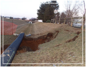
 Carbonate bedrock dissolves very slowly into the rainwater that seeps through the soil and into cracks in the rock. These cracks enlarge below the surface, hidden beneath the surface soils for a time. Eventually, a triggering event collapses the soil bridge into the bedrock opening, causing a sinkhole on the ground surface. This is a natural process, which may or may not be obvious even to a trained eye before the surface collapse. If collapse results in the failure of a structure, it is necessary to determine why the failure occurred, to avoid any additional damage. The answer to this question can be complex due to numerous potential causes such as:
- Poor planning during the initial development.
- Failure to address features that should have been recognized as having the potential to cause a failure.
- Site drainage design that resulted in the concentration of infiltrating surface water into an area susceptible to sinkhole formation.
- Alterations in surface drainage as a result of other development that result in the concentration of surface runoff.
- Leakage of water supply, waste water, or storm water lines resulting in the discharge of large quantities into the subsurface in an area susceptible to sinkhole formation.
GeoServices has experience addressing the causes of site failures. Through a careful examination of the facts, combined with an understanding of the subsurface processes, GeoServices can assess the cause of the failure and help you in planning to avoid the potential for future failures.
Storm Water Basin Assessments / Calculations
 GeoServices can complete storm water retention and detention basin calculations to assess the suitability of the soil materials within the basin. Storm water basins are designed to infiltrate storm water from a two-year storm event within a specific period of time, typically within 72 hours of the cessation of the storm event. Not only does the basin need to drain within the required time period, but no ground water mounding may occur that will impact nearby properties or buildings.
Storm Water Basin Modeling
GeoServices has completed storm water basin modeling to assess the drainage time of the basin as well as predict the extent and impact of ground water mounding in the vicinity of the basin. These calculations are critical to the proper design of storm water basins.
If you need help with your land development plans call GeoServices, Ltd. for a discussion of needs, or contact us.